 Stream monitoring collects valuable water data
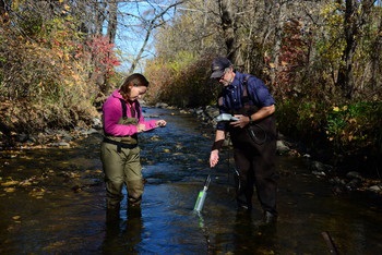
Metropolitan Council Environmental Services, with assistance from local partners, operates 20 long-term, automated stream and tributary monitoring stations. We continuously measure stage, temperature, specific conductance, and turbidity. We collect water quality samples routinely every other week and collect additional samples to capture storm events. We collect macroinvertebrate samples annual in August.
Program promotes local stewardship and decision-making
Environmental Services initiated the stream monitoring program in the 1980s, when it became clear that controlling point-source pollution alone was insufficient to meet water quality goals in the federal Clean Water Act. This program supports the Met Council’s regional planning and water quality modeling efforts and promotes local stewardship and decision-making.
Map of watersheds where we monitor streams and tribuary rivers (JPG).
Data help assess water quality trends
Data we collect characterizes the conditions of individual streams, determine the extent and sources of point- and nonpoint-source pollution in the metro area, and allow us to track water quality trends. The data help determine compliance with the state's water quality standards, shape total maximum daily load (TMDL) plans, and measure progress towards achievement of standards as best management practices are implemented.
EIMS
Source for all Environmental Services
monitoring data and additional stream river and lake reports.
Special studies
Annual reports
Watershed Outlet Monitoring Program (WOMP) Sampling Dashboard
Watershed Outlet Monitoring Program (WOMP) cooperators can use this dashboard to observe when autosamplers have registered a sample.
For more information
If you have questions about the MCES Stream and Tributary River Monitoring Program, please contact Casandra Champion at
[email protected] or 651-602-8745.