Climate Vulnerability Assessment
Regional risks and opportunities
 Evidence is mounting that Minnesota’s climate is changing, including in the seven-county metro area. Minnesota Governor Tim Walz is urging bold action across the state to address climate change: “Climate change threatens the very things that make Minnesota a great place to live, from our magnificent 10,000 lakes to our farmable land and clean air... we are taking action to reduce carbon emissions, protect public health, create jobs, and ensure our state is at the forefront of the Green Economy.”
With the aim of enhancing the lifespan of Met Council assets through a strategic and proactive planning approach, the Sustainability and Equity outcomes (PDF) within Thrive MSP 2040, as well as the Building in Resilience land use policy (PDF), direct staff to produce a regional Climate Vulnerability Assessment.
The most recent National Climate Assessment (NCA), produced by the U.S. Global Change Research Program (2023), synthesizes climate change impacts by sector and by region. The Midwest regional chapter of the NCA Report highlights current and future impacts related to climate change within Minnesota.
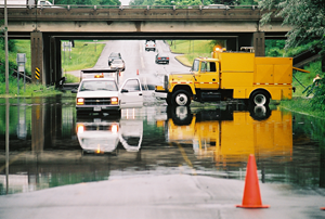
As shown in the table below, state climatologists are confident that Minnesota’s warming temperatures and increasingly severe flood events will trend upwards in the coming decades. For this reason, the Met Council’s Climate Vulnerability Assessment (CVA) focuses on regional climate hazards related to localized flooding and extreme heat.
Climate change trends in Minnesota through 2099
| Hazard |
Projections through 2099 |
Confidence in Projected Changes |
| Warming Winters |
Continued loss of cold extremes and dramatic warming of coldest conditions |
Highest |
| Extreme Rainfall |
Continued increase in frequency and magnitude; unprecedented flash-floods |
Highest |
| Heat Waves |
More hot days with increases in severity, coverage, and duration of heat waves |
High |
| Drought |
More days between precipitation events, leading to increased drought severity, coverage, and duration |
Moderately High |
| Heavy Snowfall |
Large events less frequent as winter warms, but occasional very large snowfalls |
Moderately Low |
| Severe Thunderstorms & Tornadoes |
More "super events" possible, even if frequency decreases |
Moderately Low |
Source: MN DNR State Climatology Office. Projected and expected trends among common weather hazards in Minnesota, and confidence that those hazards will change through 2099 in response to climate change. Graphic based on information from the 2014 National Climate Assessment.
Analysis, recommendations, and tools
Climate hazards can take a toll on regional investments, be it transit infrastructure or our wastewater assets. As an agency, the Metropolitan Council is responsible for maintaining regional assets and managing investments with climate change in mind. The CVA is a tool that can assist in Council and community planning efforts in preparing and adapting to climate change because the CVA can reveal system vulnerabilities to currently occurring and, to some extent, expected climatic changes.
The CVA project, and this set of webpages, consists of Council-related analysis and recommendations as well as tools for communities and other stakeholders.
We suggest that you start with the Climate Vulnerability Assessment Introduction (PDF) prior to exploring the more technical analysis of this assessment. The interactive maps below are available for community and stakeholder use. You can also find them in Tools and Resources, along with guidance on how to use each tool.